
Trees Count
Free urban trees inventory app now available on iTunes and Google Play.
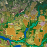
The first step in working toward a tree canopy goal is understanding what you have. Thanks to the investments of Chesapeake Bay Program partners, we are fortunate to now have ready access to “wall-to-wall” high resolution land cover/land use data for the entire watershed, for the 2013/14, 2017/18, and 2021/2022 time periods.
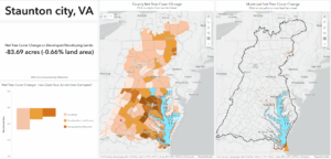
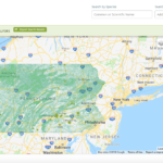
New county and municipal fact sheets are now available for all Chesapeake watershed counties sharing tree cover status, benefits (from i-Tree) and change information over the 2013/14 to 2021/22 time periods. Use the interactive tree cover map viewer below to select your county (left-side map) or municipality (right-side map) of interest and download the fact sheet. You can also access all the county and municipal fact sheets through this List of Fact Sheet Links (sorted by state and county).
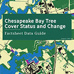
Visit the Data Guide for more information on the data sources included in the fact sheets, as well as additional resources. Access to land use/land cover map viewers, GIS datasets, and detailed methods documentation are available from Chesapeake Conservancy.
Zoom in to click on your county (left-side map) or municipality (right-side map) of interest to download the fact sheet.
Free urban trees inventory app now available on iTunes and Google Play.

Urban forest assessments are a key tool to help quantify the benefits
that trees and urban forests provide, advancing our understanding of these valuable resources.

Developing strategies for protecting and conserving ecological and cultural assets through environmentally-sensitive decisions, lifestyles, and planning.

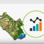
Learn how to use the i-Tree Landscape tool which combines ecosystem services calculations, demographic data and high resolution tree canopy data for the Chesapeake Bay watershed.

Learn about and download high resolution land cover data (2013), including tree canopy, produced by the Chesapeake Bay Program partnership for the entire watershed.
Short video with helpful graphics illustrating the purpose and value of UTC assessments

DC has created a suite of applications and is producing a tree inventory to engage the public in tree stewardship and ensure an enduring canopy.

A recent UTC change analysis of Baltimore, Maryland, showed that tree cover in the city increased from 27 to 28 percent over an eight-year period.
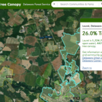
The State of Delaware has taken the initiative to make high-resolution imagery more accessible by creating the Community Tree Canopy online tool.
The Pennsylvania Community Tree Map (PATreeMap) is a free, online cloud-based mapping tool for conducting and storing tree inventories at the local level.

This tool gives Pennsylvania communities the ability to conduct tree inventories, monitoring activities, and urban tree canopy analyses, as well as track tree maintenance and stewardship activities. View webinar to learn how to use it.

A Story Map in ArcGIS Online of how the Nation’s Capital created and maintained a urban tree canopy program and how it has worked and changed over time.

In this webinar, the science of each i-Tree tool is described and the latest and upcoming i-Tree developments are discussed.
Penn State Extension’s Forest Resources describes the process of conducting a tree inventory and the four phases it can be divided into: planning, implementation, application, and maintenance.

This toolkit provides information on the steps and what goes into making an urban forest management plan.

Learn more about the Urban Tree Canopy Assessment program and find links to assessment reports.